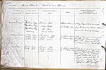
| < | List of Names as written on the Plan |
Various modes of Spelling the same Names |
Authority for those modes of Spelling |
Situation | Descriptive Remarks, or other General Observations which may be considered of Interest |
> |
|---|---|---|---|---|---|---|
| Knoutberry Rigg | Leonard Gill | About 10 chains S. | A long ridge of land running | |||
| John Varty | of Nookton Edge | along the Boundary between Allendale | ||||
| Mr Nixon | common and the County Durham | |||||
| Nutberry | Kitchin’s Co Map | |||||
| Nookton Edge | Nookton Edge | Leonard Gill | 14 Chains East | A large tract of inclined plane | ||
| Nookton Edge | John Varty | of Quick Moss | (on Allendale Common) extending | |||
| Nookton Edge | John Nixon | from the Summit of the hill | ||||
| to where it joins Quick Cleugh | ||||||
| Quick Moss | Quick Moss | Leonard Gill | 14 Chains West | This portion of Moorland is raised | ||
| Quick Moss | John Varty | of Nookton Edge | in Small heaps from three to four | |||
| John Nixon | feet above the common surface it | |||||
| caused by the under water or | ||||||
| floods which give Rise to | ||||||
| the name Quick Moss | ||||||
| which name applies to many | ||||||
| objects in that locality | ||||||
| Thomas Grehan Civil Assistant |
Abbreviations are underlined like this RE and the expansion may be seen by hovering the cursor over the abbreviation.
| An entry outlined like this has a note which may be seen by hovering the cursor over it. |
Transcribed by MP
Return to Allendale 332 index