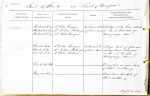
| < | List of Names as written on the Plan |
Various modes of Spelling the same Names |
Authority for those modes of Spelling |
Situation | Descriptive Remarks, or other General Observations which may be considered of Interest |
> |
|---|---|---|---|---|---|---|
| Monkside Crag | Monkside Crag | Mr John Thompson | 23 chains S. W. | A steep rocky brow situated | ||
| Monkside Crag | Mr William Rutherford | of Dun Knowe | on the N. West side of | |||
| Monkside Crag | Mr Walter Thompson | Burngrange Moor. | ||||
| Buck Lake | Buck Lake | Mr Walter Thompson | 28 chains S. E. | A large tract of flat wet | ||
| Buck Lake | Mr William Rutherford | of Dun Knowe | mossy land situated | |||
| Buck Lake | Mr John Robson | on the N. West side of | ||||
| Burngrange Moor. | ||||||
| Buck Lake Sike | Described in name book | |||||
| of Sheet 50 plan 9. | ||||||
| Harper’s Burn | Described in name book of | |||||
| Sheet 50 plan 9. | ||||||
| M Costelloe Civil Assistant |
Abbreviations are underlined like this RE and the expansion may be seen by hovering the cursor over the abbreviation.
| An entry outlined like this has a note which may be seen by hovering the cursor over it. |
Transcribed by TH
Return to Thorneyburn index