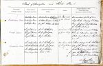
| < | List of Names as written on the Plan |
Various modes of Spelling the same Names |
Authority for those modes of Spelling |
Situation | Descriptive Remarks, or other General Observations which may be considered of Interest |
> |
|---|---|---|---|---|---|---|
| Emblehope Moor | Emblehope Moor | Mr Archibald Rutherford (Emblehope) | In the North | The unenclosed portion of land | ||
| Emblehope Moor | Mr Walter Thompson, Emblehope | of the Parish | chiefly heathy belonging to Emblehope | |||
| Emblehope Moor | Mr John Robson (The Dodd) | Farm. The property of the Duke | ||||
| of Northumberland. | ||||||
| Lough Knowe | Lough Knowe | Mr A. Rutherford | 34 chains N. E. | A slight eminence on Emblehope | ||
| Lough Knowe | Mr W. Thompson | of Green Bog. | Moor, so called from a quantity | |||
| Lough Knowe | Mr J. Robson | of water being collected in a hag hole | ||||
| near it. | ||||||
| Smalehope Burn | Smalehope Burn | Mr A. Rutherford | 26 chains South | A stream rising on the North West | ||
| Smalehope Burn | Mr W. Thompson | of Lough Knowe. | side of this parish. It flows in a | |||
| Smalehope Burn | Mr J. Robson | on 50/10 | South Westerly direction till it | |||
| Smalehope Burn | Tithe Plan | joins the |
||||
| form the head of Tarset Burn. | ||||||
| James Sloan Sapper Royal Engineers |
Abbreviations are underlined like this RE and the expansion may be seen by hovering the cursor over the abbreviation.
| An entry outlined like this has a note which may be seen by hovering the cursor over it. |
Transcribed by TH
Return to Thorneyburn index