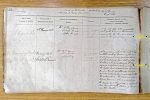
| < | List of Names as written on the Plan |
Various modes of Spelling the same Names |
Authority for those modes of Spelling |
Situation | Descriptive Remarks, or other General Observations which may be considered of Interest |
> |
|---|---|---|---|---|---|---|
| St Gregory’s Hill | St Gregory’s Hill | Mr. A. Thompson | on Sheets | A low but steep hill immediately | ||
| Estate Map | 19. 1 & | South of the Village of Kirknewton | ||||
| Tythe Map | 19. 2 | and on the top, there is a small | ||||
| ancient Camp. | ||||||
| Yeavering Bell | Yeavering Bell | Mr. Robt Brown | on Sheet | A mountain about 2000 feet high | ||
| (Druidical Remains) | (Druidical Remains) | Mr. Wm Short | 19. 2 | a little South of Yeavering farm. | ||
| Directory | On its summit is an enclosed place | |||||
| of about 13 acres, by a belt of loose | ||||||
| boulders which are supposed to have | ||||||
| formed a defensive wall in olden times, | ||||||
| the highest point is surrounded by a small | ||||||
| circular trench, and there are several | ||||||
| minute circles visible round about within | ||||||
| the enclosed space, the whole are supposed | ||||||
| to have formed a retreat of safety for | ||||||
| the Druids, and this place is supposed to | ||||||
| have been a princip |
||||||
| in the North. | ||||||
| Robt Young Corporal Royal Engineers |
Note: Signature in header, 'Collected by'
Abbreviations are underlined like this RE and the expansion may be seen by hovering the cursor over the abbreviation.
| An entry outlined like this has a note which may be seen by hovering the cursor over it. |
Transcribed by ARJC
Return to Kirknewton index